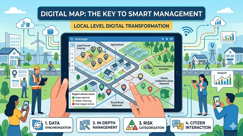
Introduction
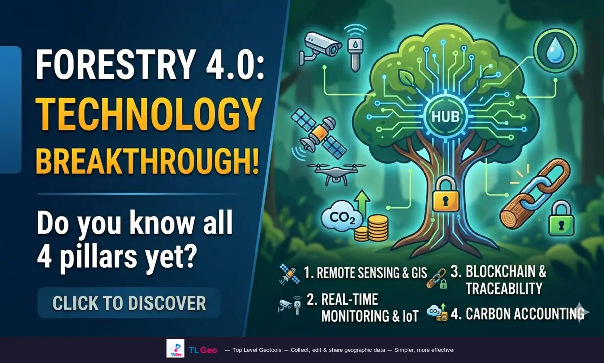
Forestry is undergoing a major shift from manual management to real-time data-driven monitoring — known as Forestry 4.0. The combination of remote sensing, IoT, blockchain and artificial intelligence is redefining how we protect and manage forest resources.
This article covers 4 key technology pillars that every GIS project in forestry should understand.
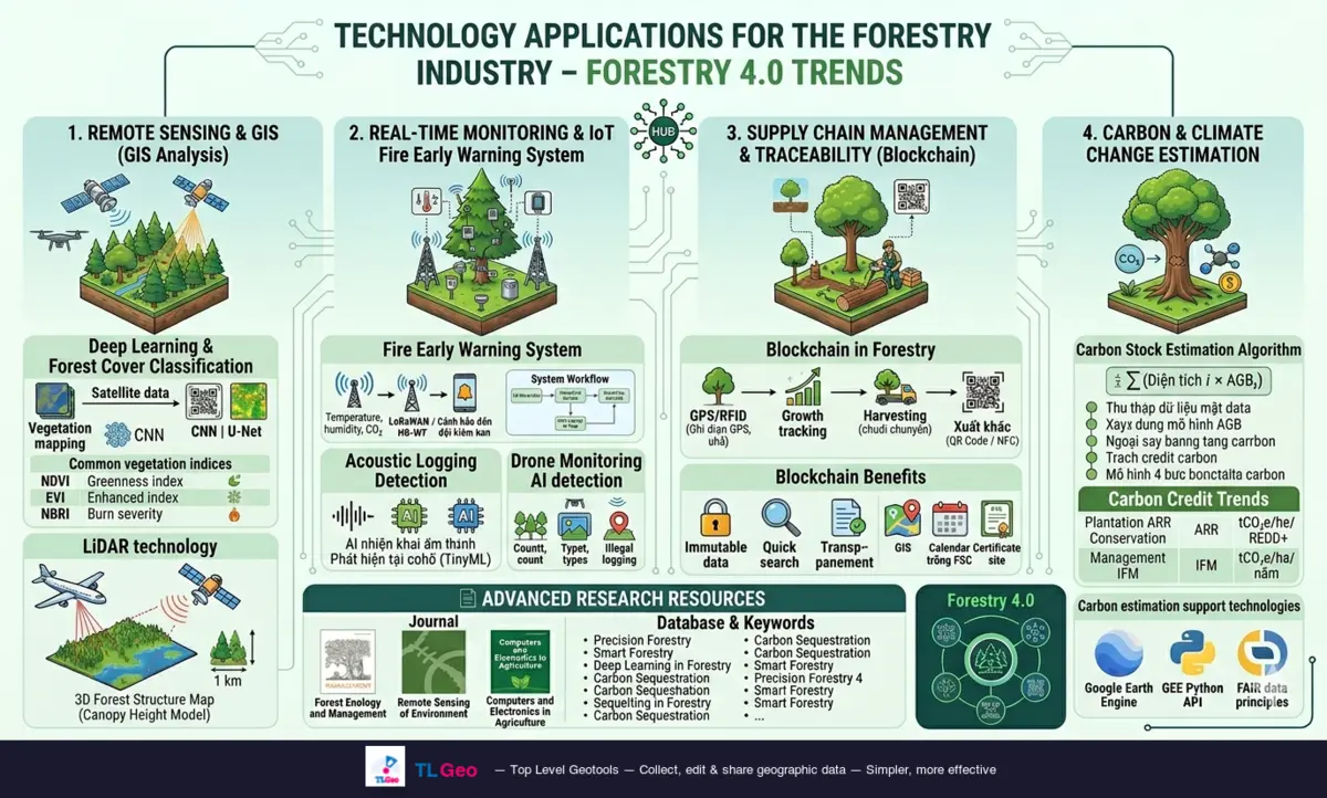
1. Remote Sensing & Image Analysis
This is the most important area for monitoring forest coverage at large scale, serving inventory, deforestation detection and change assessment.
1.1. Deep Learning in Forest Cover Classification
Recent studies use Convolutional Neural Networks (CNN) with Sentinel-2 and Landsat 8 satellite data to:
- Detect deforestation in near-real-time
- Identify land-use change patterns
- Classify tree species in natural forests
Common workflow:
Satellite data (Sentinel-2 / Landsat)
    ↓
Pre-processing (radiometric correction, cloud removal)
    ↓
Index extraction (NDVI, EVI, NDWI...)
    ↓
CNN classification model (U-Net, ResNet...)
    ↓
Forest cover map / Change detection map
Common remote sensing indices in forestry:
| Index | Meaning |
|---|---|
| NDVI | Vegetation greenness, tree health |
| EVI | Photosynthetic efficiency, less saturated than NDVI |
| NDWI | Leaf water content, detect drought stress |
| NBR | Burn severity, distinguish regenerating forest |
1.2. LiDAR Technology in Forestry
LiDAR (Light Detection and Ranging) emits laser pulses and measures return time, producing a 3D point cloud that enables:
- Building 3D canopy structure maps (Canopy Height Model)
- Measuring tree height to meter-level accuracy
- Estimating biomass and carbon stock
- Distinguishing canopy layers in multi-story forests
Specific applications:
| LiDAR Type | Source | Application |
|---|---|---|
| Airborne LiDAR | Drone/Aircraft | Large-area forest inventory |
| Terrestrial LiDAR | Ground scanner | Detailed forest structure |
| Satellite LiDAR | GEDI / ICESat-2 | Global carbon monitoring |
💡 Tip: Combine LiDAR + multispectral satellite data for the most accurate biomass estimation model.
2. Real-Time Monitoring and IoT
For applications focused on forest protection and early warning, IoT is an essential pillar.
2.1. Early Forest Fire Warning Systems
A typical fire warning system includes:
- Wireless Sensor Network (WSN): Temperature, humidity, CO₂, smoke sensors
- Infrared thermal sensors: Remote hotspot detection
- Surveillance cameras: AI-powered smoke and fire detection
- Gateway data transmission: LoRaWAN / NB-IoT sending to central server
System workflow:
Temperature/humidity sensors → Gateway (LoRaWAN)
    ↓
Real-time data transmission to Server
    ↓
Analysis with fire prediction models (FPI, FWI)
    ↓
SMS/Zalo alert to forest rangers
2.2. Illegal Logging Detection via Acoustic Monitoring
An emerging trend using AI sound recognition in forests:
- Chainsaw sounds: Detecting logging activity
- Truck sounds: Tracking illegal timber transport
- Gunshots: Alerting for poaching incidents
Underlying technology:
- TinyML on edge devices (on-site detection without internet)
- Recurrent Neural Networks (RNN/LSTM) for sound classification
- AudioSet / ESC-50 as training datasets
2.3. Drones in Forestry Monitoring (UAVs in Forestry)
Drones combined with AI are becoming essential tools:
- Automatic tree counting with object detection (YOLO, Faster R-CNN)
- Multispectral imagery for NDVI mapping on small areas
- Deforestation hotspots via before/after image comparison
- Forest transport monitoring — surveillance of logging roads
3. Supply Chain Management and Traceability (Blockchain)
Forestry faces increasingly strict regulations on legal timber — notably the EUDR (EU Deforestation Regulation), in effect since late 2024.
3.1. Blockchain in Forestry
Blockchain digitizes the lifecycle of a tree from planting to finished product:
Planting → Record GPS, photos, area info on Blockchain
    ↓
Growth monitoring → Periodic remote sensing data updates
    ↓
Harvesting → Record volume, transport chain
    ↓
Processing → Manufacturing process recorded
    ↓
Export → QR Code / NFC for customs traceability
Benefits of Blockchain:
- Tamper-proof — ensures transparency
- Fast lookup — check provenance in seconds
- EUDR compliance — prove timber is deforestation-free
3.2. FSC Plantation Management
FSC (Forest Stewardship Council) requires plantation managers to record:
- Area coordinates (GIS)
- Management history (pruning, pesticide application)
- Chain-of-custody certification
Geocollect can support field data collection and export to formats compatible with traceability systems.
4. Carbon Estimation and Climate Change
This area attracts the most investment currently, especially related to Carbon Credits.
4.1. Carbon Stock Estimation Algorithms
Mathematical models combining ground data and remote sensing to calculate CO₂ absorbed by forests:
Basic formula:
Total Carbon = Σ (Area_i × AGB_i)
Where: AGB (Above-Ground Biomass) = f(NDVI, LiDAR height, species)
CO₂ equivalent = Total Carbon × 3.67
Estimation steps:
- Ground data collection (field sampling): measure circumference, height, species
- Build AGB model using allometric equations
- Extrapolate via remote sensing: use NDVI, LiDAR, SAR to scale across area
- Carbon audit by accredited organization (VERRA, Gold Standard)
4.2. Carbon Credit Trends in Forestry
| Activity | Credit Type | Unit |
|---|---|---|
| New plantation | ARR | tCO₂e/ha |
| Protecting existing forest | REDD+ | tCO₂e/ha/year |
| Sustainable forest management | IFM | tCO₂e/ha/year |
4.3. Technologies supporting carbon calculation
- Google Earth Engine: Batch process Landsat/Sentinel, calculate NDVI trends
- GEE Python API: Automate carbon calculation by area
- FAIR data principles: Carbon data must meet FAIR standards (Findable, Accessible, Interoperable, Reusable)
Deep Research Resources
Academic journals
- Forest Ecology and Management — forest ecology research
- Remote Sensing of Environment — applied remote sensing
- Computers and Electronics in Agriculture — AI technology in agriculture/forestry
Databases and keywords
| Keyword | Topic |
|---|---|
| Precision Forestry | Precision agriculture/forestry |
| Smart Forestry | Smart forestry |
| Deep Learning in Forestry | AI in forestry |
| Forest Inventory | Forest inventory |
| Canopy Cover | Canopy cover |
| Tree Species Classification | Tree species classification |
| UAVs in Forestry | Drone applications |
| Carbon Sequestration | Carbon sequestration |
| Acoustic Monitoring | Acoustic monitoring |
Conclusion
Forestry 4.0 is not just a buzzword — it’s a real transformation underway. The 4 technology pillars above complement each other:
- Remote sensing provides baseline data — large-area monitoring
- IoT delivers real-time data — rapid detection
- Blockchain ensures transparency — regulatory compliance
- Carbon estimation creates economic value — attracts investment
💡 Practical tip: Start by collecting accurate GPS data in the field with Geocollect — this is the foundation for all subsequent remote sensing, IoT or carbon analysis.
If you need GIS consulting for your forestry project, feel free to contact TLGeo.