Challenges: “Bottlenecks” in Traditional Management
In the digital transformation era, forestry faces a paradox: increasingly large management areas, stricter international certification requirements, yet management methods at many locations remain stuck with notebooks and paper maps.
Most forest management organizations today face three major barriers:
- Information discontinuity: Field data (patrol, changes) often takes a long time to reach the office. By the time leadership receives reports, events (like deforestation, forest fires) have usually already occurred.
- “Static” data on paper: Paper maps and scattered Excel files make querying forest plot history slow. Calculations of timber volume, area, or harvest planning lack absolute accuracy.
- Transparency pressure: International standards (FSC, PEFC) and Carbon credit projects require a data storage system that cannot be tampered with and has immediate traceability.
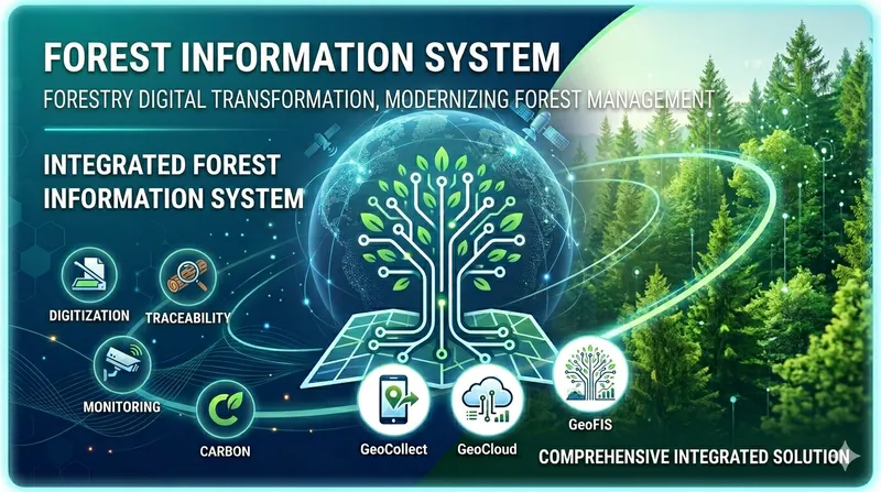
Theory: What is a Forest Information System (FIS)?
To solve these challenges, the concept of Forest Information System (FIS) has been standardized by international organizations like UNECE. FIS is not just software, but a process that transforms data into knowledge:
- Data: Collect raw numbers (tree counts, coordinates).
- Information: Connect numbers to understand status (forest plot timber volume, management boundaries).
- Knowledge: Analyze information to make decisions (which areas need strict protection, which areas are eligible for harvesting).
FIS serves as a Decision Support System (DSS), helping managers no longer have to “guess” but “know” exactly what is happening under the forest canopy.
TLGeo Solution: “End-to-End” Technology Ecosystem
Based on international FIS theory and field experience in Vietnam, TLGeo delivers a comprehensive integrated solution, bridging the gap between deep forest and operations office.
Data Collection Technology: GeoCollect
The “eyes and ears” in the field. Mobile application allows forest rangers to:
- Record forest changes on-site with images and GPS coordinates.
- Work perfectly in Offline conditions (no phone signal).
- Sync data with “one touch” when network is available.
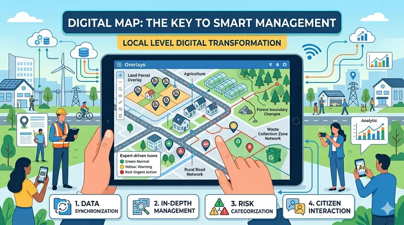
Management Platform: GeoCloud (WebGIS)
The central “brain” where field data converges:
- Display multi-layer real-time forest status maps.
- Integrate satellite image comparison algorithms to automatically alert deforestation points.
- Automated reporting system helps export forestry forms in seconds.
Professional Connectivity: Plugin System
For professional GIS engineers, enabling direct two-way data synchronization between Web Cloud environment and dedicated software like QGIS or MapInfo.
Distributed Data
The system is designed to manage data from multiple points, ensuring integrity and traceability.
Conclusion
Digital transformation in forestry is no longer an option, but a mandatory requirement for sustainable development. With the combination of international management theory and powerful tools from TLGeo, we commit to helping forest owners:
- Master forest resources
- Optimize resources
- Be ready for new opportunities in the green economy
TLGeo - Comprehensive solutions for sustainable forest resources.
Scenario: A Day of Digital Transformation at Forest Management Office
To visualize the real value of TLGeo FIS, let’s follow a typical workday:
Characters:
- Mr. Hung: Field forest ranger (using GeoCollect)
- Ms. Lan: Technical director at the operations center (using GeoCloud WebGIS)
08:00 AM – Assigning tasks at the office
At the operations center, Ms. Lan opens GeoCloud WebGIS. The map shows an area in dark red – the result of an automated satellite image comparison algorithm from last night, suspected of forest change.
She draws a boundary around the suspicious area and sends a field inspection request directly to Mr. Hung’s tablet. No more guessing or waiting for verbal reports.
09:30 AM – Field patrol with GeoCollect
Mr. Hung drives deep into the forest – where there’s absolutely no 4G/5G signal. He opens GeoCollect with offline map showing his exact GPS position. He follows the pre-planned track log to reach the flagged forest plot.
At the change site, he discovers an area illegally converted for farming. Using GeoCollect:
- Take photos of the current situation
- Quickly draw the boundary of the encroached area on the touchscreen
- Select violation type: “Forest land encroachment”
Value: Works perfectly with no network. All information is packaged accurately.
02:00 PM – “One-touch” data sync
Mr. Hung returns to the ranger station with Wi-Fi, presses “Sync”. All field data immediately uploads to GeoCloud.
Value: Completely eliminates the need to return to the office to transfer photos, redraw maps manually, or re-enter data into Excel. Saves 80% of reporting time.
03:30 PM – Analysis and Decision-making at the Center
Ms. Lan’s screen displays Mr. Hung’s report notification. She clicks on the report point, views field photos and violation area (already calculated by the system). Uses Query feature on WebGIS to check which management unit this forest plot belongs to, and its protection history.
Value: Leadership gets instant visibility and authentic evidence to sign violation handling documents or mobilize support forces.
04:30 PM – Quick report export
Time for the periodic report for the Department. Ms. Lan selects “Monthly Change Report”, the system automatically aggregates all data from Mr. Hung and other teams. In 30 seconds, a professional PDF file with complete maps and statistical tables is exported.
Value: “Spotless” accuracy without manual data entry errors. Reports are always ready with just one click.
Slogan: “Bringing technology from the Lab into the heart of the forest.”