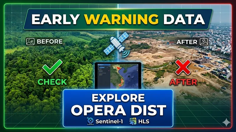
In an era of rapid environmental shifts, knowing where and when land disturbance occurs is critical for conservation and resource management. Today, we’re diving into a powerful new tool in the remote sensing arsenal: the OPERA Land Surface Disturbance (DIST) product suite.
1. What is OPERA DIST?
The DIST product suite is designed to map surface disturbances whenever a change falls outside of historical norms. By leveraging both optical and Synthetic Aperture Radar (SAR) imagery, it provides a high-fidelity look at how our landscapes are evolving.
The suite is powered by two primary data streams:
- Sentinel-1: Providing robust radar data that “sees” through clouds.
- Harmonized Landsat Sentinel-2 (HLS): A seamless blend of NASA’s Landsat and ESA’s Sentinel-2 imagery.
2. Meet the DIST Family
The products are built with a unified architecture, sharing the same GeoTiff format, naming conventions, and a sharp 30m spatial resolution. There are two main variants based on their timeframe:
DIST-ALERT
The “rapid responder.” It tracks disturbances at the cadence of HLS imagery, providing near-real-time updates. Perfect for reacting to events as they happen.
DIST-ANN
The “annual summary.” It provides a comprehensive overview of DIST-ALERT detections over the previous year—perfect for long-term trend analysis, reporting, and research.
3. Why It Matters for Developers and Researchers
OPERA doesn’t just give you raw data; they provide a full ecosystem for analysis:
- Accessibility: All products are hosted at the LP DAAC (Land Processes Distributed Active Archive Center).
- Open-Source Friendly: The suite includes interactive guides for loading data into open-source GIS packages.
- Ready-to-Code: Interactive white papers via Jupyter Notebooks showcase specific applications and help you get started with Python-based analysis.
4. Real-World Applications
How can you use this data today?
- Deforestation Monitoring: Identify illegal logging activities as they happen.
- Urban Expansion: Map the footprint of new infrastructure and housing developments.
- Disaster Assessment: Evaluate the impact of wildfires, floods, or landslides.
Final Thoughts
The OPERA DIST suite represents a significant step forward in making Earth observation data actionable. Whether you are a scientist tracking climate impacts or a GIS analyst monitoring local land use, these 30m resolution products offer the precision and frequency needed to stay ahead of the curve.
Pro Tip: New to the data? Check out the Product Specification Document and download the Product Samples from the LP DAAC to explore the metadata and structure before diving into your full-scale project.
Reference: NASA JPL - OPERA DIST Product Suite